Casa Minerals Commences Inaugural Diamond Drilling at the Arsenault Copper-Gold-Silver Project, British Columbia
Vancouver, BC, Sept 22, 2026 - (ACN Newswire) - Casa Minerals Inc. (TSXV: CASA) (OTCQB: CASXF) (FSE: 0CM) (the "Company" or "Casa") is pleased to announce that diamond drilling has commenced at its Arsenault copper-gold-silver volcanogenic massive sulphide ("VMS") project (the "Property" or "Arsenau

Vancouver, BC, Sept 22, 2026 - (ACN Newswire) - Casa Minerals Inc. (TSXV: CASA) (OTCQB: CASXF) (FSE: 0CM) (the "Company" or "Casa") is pleased to announce that diamond drilling has commenced at its Arsenault copper-gold-silver volcanogenic massive sulphide ("VMS") project (the "Property" or "Arsenault"), located in the Jennings River area of northern British Columbia, approximately 130 kilometres east-northeast of Atlin, BC, near the Yukon border. This is the first drilling ever carried out by Casa at Arsenault and one of the first modern drill tests of the Arsenault VMS system.
First Hole of the Inaugural Program
The first hole of the program is collared on IP survey Line 15E at UTM coordinates Easting 347,110 mE and Northing 6,632,206 mN (UTM Zone 9N). The hole is oriented at an azimuth of 045° (N45°E) with a dip of -85° - a near-vertical attitude selected to intersect, at relatively shallow depth, the sub-vertical chargeability and resistivity feature defined by the Company's 2025 ground induced polarization ("IP") survey. The collar is positioned directly over a first-priority IP anomaly characterized by strong chargeability and low-to-moderate resistivity, coincident with an interpreted fault/contact - the geophysical signature the Company considers most prospective for massive sulphide mineralization on the Property (Figure 1).
Table 1: Table 1: Arsenault 2026 inaugural drill hole - collar location and orientation
| Item | Inaugural hole - collar and orientation |
| Survey line | Line 15E (200 m line spacing) |
| Collar location (UTM Zone 9N) | 347,110 mE / 6,632,206 mN |
| Azimuth | 045° (N45°E) |
| Dip | -85° |
| Primary target | First-priority IP anomaly - strong chargeability, low-to-moderate resistivity, coincident interpreted fault/contact |
| Access | Helicopter-supported, temporary camp |
Basis of Drill Targeting
Drill targets for the inaugural program were generated by integrating property-scale geological mapping, surface rock and soil geochemical sampling, the Company's large database of historic exploration data, the 2017 airborne VTEM survey that originally outlined five VMS targets on the Property, and - most importantly - the three-dimensional inversion products of the 2025 ground IP survey. The Company's technical team ranked the resulting anomalies on the combined strength of chargeability, resistivity, structural setting and geological/geochemical support, and has scheduled the first holes of the program on the highest-ranked targets. The first-priority targets exhibit strong chargeability responses coincident with low resistivity, a combination characteristic of, though not diagnostic of, massive sulphide mineralization.
2025 Alpha IP Survey and Results
The 2025 program, completed by Simcoe Geoscience Limited ("Simcoe") between September 1 and 24, 2025, employed the Alpha IP™ wireless time-domain distributed IP system using a dipole-pole-dipole array configuration with 100-metre station spacing and 200-metre line spacing. Fifteen (15) profiles were acquired for a total of 34.5 line-kilometres, with a depth of investigation of 500 metres or more. The survey was designed to map chargeability and resistivity features associated with potential copper, gold and silver mineralization in the Big Salmon volcano-sedimentary sequence that hosts the Arsenault VMS system.
The survey identified 71 discrete anomalies: 29 first-priority targets exhibiting strong chargeability and low resistivity; 24 second-priority targets with moderate chargeability and resistivity; and 18 deeper-seated third-priority anomalies, some of which appear to be depth extensions of the shallower targets. Six northwest-southeast trending anomalous corridors were identified, following the regional structural grain and associated with interpreted faults and geological contacts. A major inferred fault running through the centre of the survey area separates a southwestern domain of strong to moderate chargeability coincident with low resistivity - considered prospective for VMS-style mineralization - from a northeastern domain of moderate to weak chargeability coincident with moderate to high resistivity (Figure 2).
Table 2: Table 2: 2025 Alpha IP survey - interpreted anomaly summary (after Simcoe Geoscience Limited, report SGL-25398, October 28, 2025)
| Priority | Geophysical signature | Anomalies | Interpretation |
| First | Strong chargeability, low resistivity | 29 | Potential zones of significant sulphide mineralization (e.g. massive sulphides) |
| Second | Moderate chargeability and resistivity | 24 | Possible mineralized structures (e.g. disseminated sulphides); lower confidence |
| Third | Deeper-seated chargeability | 18 | Possible depth extensions of shallower targets; some isolated |
| Total | 71 |
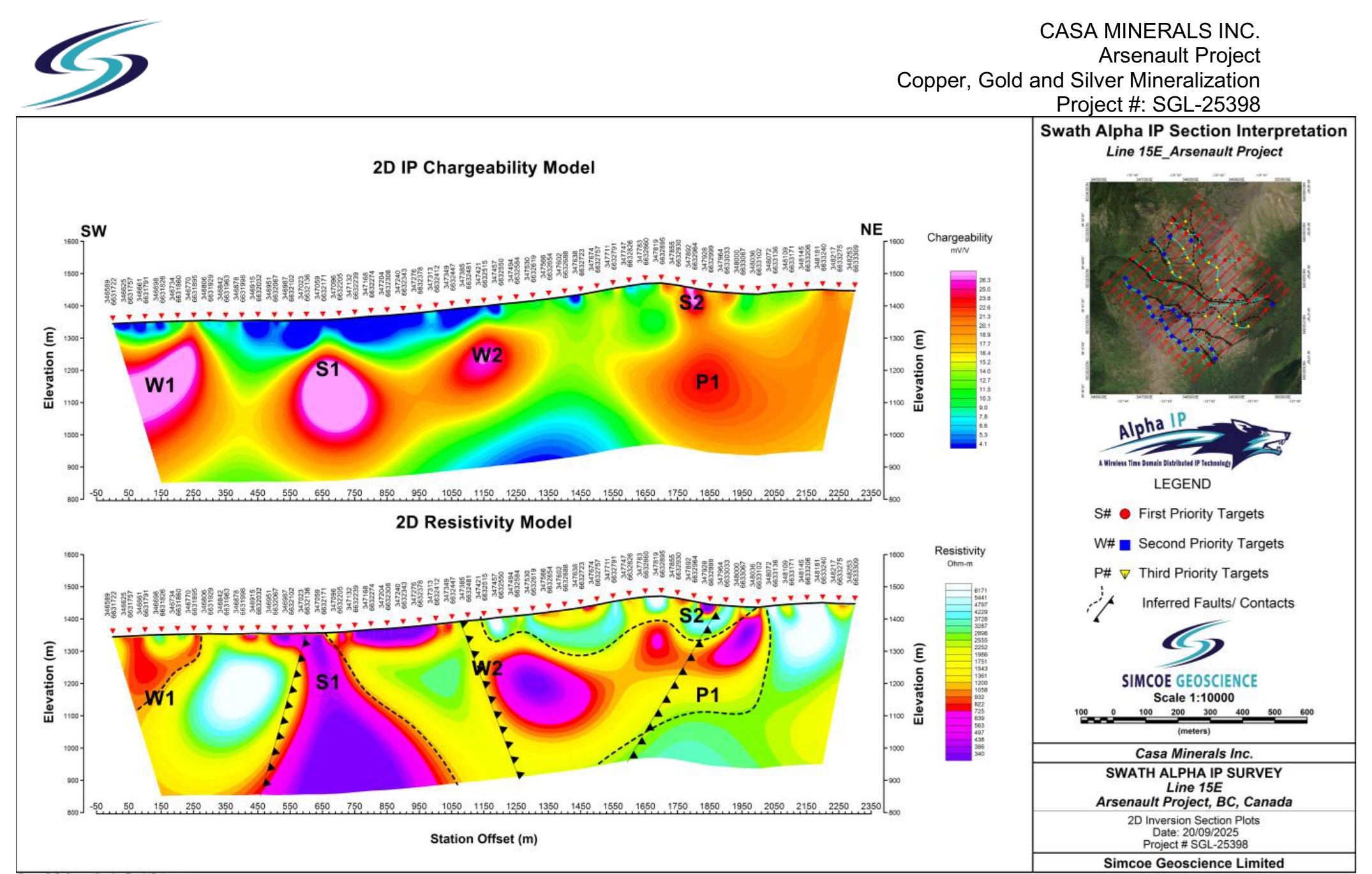
Figure 1: Line 15E - interpreted IP chargeability (upper) and resistivity (lower) cross-sections, showing first-priority targets (S), second-priority targets (W), third-priority targets (P) and interpreted faults/contacts. The 2026 inaugural hole is collared on this section over the first-priority anomaly identified on this line. (Source: Simcoe Geoscience Limited, report SGL-25398)
To view an enhanced version of this graphic, please visit:
https://images.newsfilecorp.com/files/1750/315392_8537ba8ec431c90d_001full.jpg
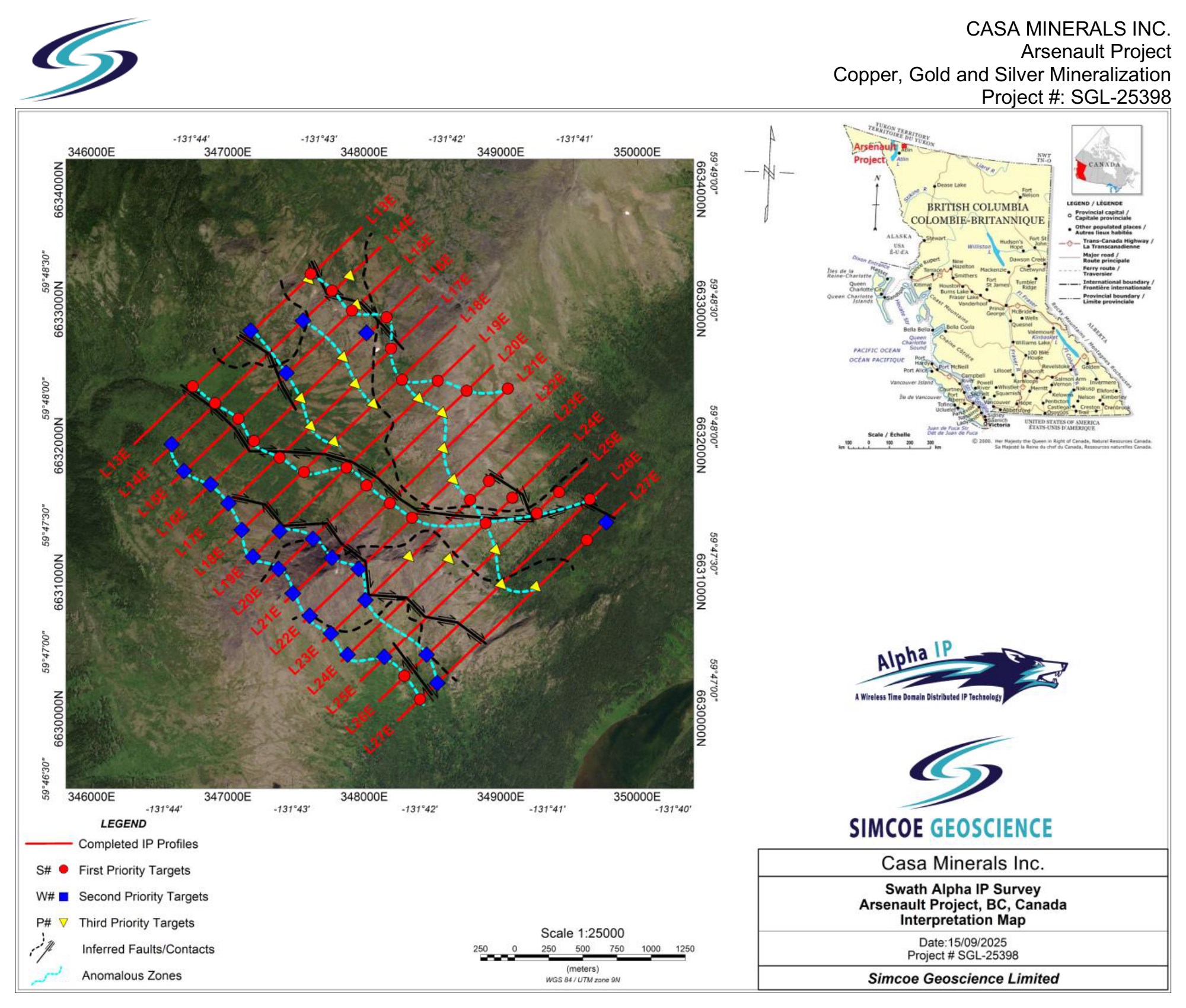
Figure 2: Arsenault Project - 2025 Alpha IP survey interpretation map showing first-priority targets (red circles), second-priority targets (blue squares), third-priority targets (yellow triangles), interpreted faults/contacts (dashed) and anomalous corridors, with the survey lines L13E to L27E. (Source: Simcoe Geoscience Limited, report SGL-25398)
To view an enhanced version of this graphic, please visit:
https://images.newsfilecorp.com/files/1750/315392_8537ba8ec431c90d_002full.jpg
Permitting and Program Logistics
Drilling is being conducted under the Company's five-year area-based exploration permit issued by the British Columbia Ministry of Energy, Mines and Low Carbon Innovation in June 2024. The permit authorizes up to 80 line-kilometres of ground geophysical surveying and drilling from 30 helicopter-accessed drill sites. The permitting process included consultation with the Teslin-Tlingit First Nation and the Taku River Tlingit First Nation, within whose traditional territories the Property is located, and incorporates provisions for environmental protection. The program is helicopter-supported with personnel accommodated in a temporary camp, and all environmental and social protocols are being strictly observed.
Program Supervision and Quality Assurance
The drill program is being supervised by a Qualified Person, who is responsible for the supervision of drilling operations, custody of drill core, and the management of core records and sampling. Core will be logged, photographed and sampled in accordance with industry-standard QA/QC procedures; one half of each sampled interval will be submitted to an independent, ISO-certified commercial analytical laboratory, with the remaining half retained in secure storage. Assay results will be released following receipt, verification and compilation.
Management Commentary
"This is an exciting and significant milestone for Casa," commented Farshad Shirvani, President, CEO and Director of Casa Minerals Inc. "The drill is the ultimate arbiter of truth in this business, and it will tell us what we need to know. Our responsibility is to give it the best possible chance. By bringing together our geological mapping, surface sampling, the historic airborne electromagnetic data and, most importantly, the three-dimensional inversion of the 2025 IP survey, we have ranked and selected our strongest targets and will test those first. There are many more anomalies on this property, but this is a great place to start. What we have learned from applying 3D IP to our other discoveries is what gives us confidence in the ranking of these targets, and we look forward to reporting results."
About the Arsenault Project
Arsenault comprises 9,672 hectares (23,653 acres) in the Jennings River area of northwestern British Columbia and is a VMS prospect first identified in 1947. The Property hosts the historic Arsenault VMS1 zone and a 2017 airborne VTEM survey outlined five VMS targets, including four previously unknown target areas. Mineralization identified on the Property includes bornite, chalcopyrite and pyrite, with considerable gold and silver values accompanying the copper. Historic work has reported rock assays from the VMS1 zone of up to 1.74% copper, 0.98 g/t gold and 24.1 g/t silver, and copper-in-soil values of up to 0.54%. These historic values are reported for context only and have not been verified by a Qualified Person. Casa holds an option to acquire a 75% interest in the Arsenault Property.
Cautionary Notes
The geophysical anomalies described in this news release are interpreted responses of the subsurface to the induced polarization and resistivity survey and do not necessarily represent mineralization, mineral grade or the full extent of any mineralized body. Anomalies of similar response amplitude may be produced by non-mineralized geological, structural and mineral assemblages. The presence of an anomaly is not a guarantee that drilling will intersect mineralization of economic interest.
The historic assay values, production figures and exploration results referenced in this news release were obtained from available archives and have not been confirmed or verified by the Company or by a Qualified Person. They are disclosed solely for context, do not conform to current National Instrument 43-101 ("NI 43-101") standards, and should not be relied upon. The Arsenault Project does not currently host any mineral resource or mineral reserve estimated in accordance with NI 43-101, and there is no assurance that exploration will result in the identification of an economically viable mineral deposit.
Qualified Person
Mr. Erik Ostensoe, P.Geo., a Director and Chief Geologist of the Company and a Qualified Person as defined by National Instrument 43-101, has reviewed and approved the scientific and technical disclosure in this news release.
About Casa Minerals Inc.
Casa Minerals Inc. is engaged in the acquisition, exploration and development of mineral properties located in Canada and the USA. Casa owns a ninety percent (90%) interest in the historic Congress gold mine (Arizona, USA) and owns a one hundred percent (100%) interest in the polymetallic Pitman and Keaper properties (BC, Canada). The Company also holds an option to acquire a seventy-five percent (75%) interest in the Arsenault copper-gold-silver VMS Property (BC, Canada). Casa's management team has a track record of discoveries in the exploration sector and is committed to creating shareholder value through the discovery and development of economic mineral deposits.
On Behalf of the Board of Directors
Farshad Shirvani, M.Sc. Geology
President, CEO and Director
For more information, please contact:
Casa Minerals Inc.
Farshad Shirvani, President & CEO
Phone: (604) 678-9587
Email: contact@casaminerals.com
https://www.casaminerals.com
NEITHER TSX VENTURE EXCHANGE NOR ITS REGULATION SERVICES PROVIDER (AS THAT TERM IS DEFINED IN THE POLICIES OF THE TSX VENTURE EXCHANGE) ACCEPTS RESPONSIBILITY FOR THE ADEQUACY OR ACCURACY OF THIS RELEASE.
Certain of the statements made and information contained herein may constitute "forward-looking information" within the meaning of applicable Canadian securities legislation. Forward-looking information includes, but is not limited to, statements regarding the Company's planned drilling and exploration programs at the Arsenault Project, the interpretation of geophysical data, the potential for mineralization, the timing and receipt of assay results, and the Company's ability to satisfy the conditions of its option over the Property. In particular, references to future work programs and expectations on the quality or results of such work programs are subject to risks associated with operations on the property, exploration activity generally, equipment limitations and availability, the accuracy of geophysical and geochemical interpretations, the speculative nature of mineral exploration, permitting and regulatory risks, availability of financing, commodity prices, and other risks that we may not be currently aware of. Accordingly, readers are advised not to place undue reliance on forward-looking information. Actual results may differ materially from those anticipated. Except as required under applicable securities legislation, the Company undertakes no obligation to publicly update or revise forward-looking information, whether as a result of new information, future events or otherwise.

To view the source version of this press release, please visit https://www.newsfilecorp.com/release/315392
Copyright 2026 ACN Newswire. All rights reserved. www.acnnewswire.com
Tokyo Overnight
Japan markets, decoded. Get the brief in your inbox.
No spam. Unsubscribe anytime.